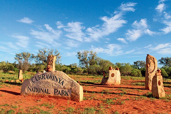
Currawinya National Park, Qld
|
|
Time to read 4 min
|
|
Time to read 4 min
Did you know that one of Australia’s most important wetlands is in far western Queensland, in a remote, arid and isolated area? About 900km west of Brisbane, just above the Wild Dog Fence (formally the Dingo Fence), is Currawinya National Park (NP) and, at nearly 155,000ha, it’s a great place to visit on a camping trip to explore the hidden secrets within the park.
The park lies on the northern side of the Paroo River and access can be gained from two directions. All roads leading and in the park are unsealed and are maintained on an irregular basis and it is camper-trailer friendly, but you need to be well prepared as this beautiful place is harsh and remote, and you may not see another camper during your stay.
From the north, head out to Eulo in western Queensland along the Adventurer Way and then south for 100km along the Hungerford Road. This unsealed sandy/rocky road is wide and generally in a reasonable condition for the area. As you travel on the western side of the Paroo River, you’ll pass through remote private stations. For much of the 100km, the road is fairly flat with only a few large undulations which gives you a view across the plains towards more scrubby country. The biggest hazard out here is the wildlife and stock along the way with emus, goats, kangaroos, cattle, snakes and lizards all likely to cross the road in front of you when you least expect it.
The southern entry to the park is via Hungerford, 220km north-west of Bourke and right on the NSW/Qld border, although it does have a Queensland postcode.
The roads to and within the park can be impassable when wet due to creek crossings and flooding from the Paroo River, so road condition information should be sourced from the NPWS website or local information at Eulo, Cunnamulla or Hungerford before travelling to Currawinya.
Mid-way into the park, you’ll be greeted by Currawinya’s stunning rock formations and the nearby park information boards. This is a great spot to take five and read up on the history and other features of the park and also take a walk among the sandstone sculptures.
You can wander through the old shearers’ shed and it’s fantastic to see everything still in pristine condition after 60,000 sheep were shorn here. Walking around the stalls, monkey press, scales, sorting rack and slips, it looks like it wouldn’t take much to get it up and firing again.
Not many people realise that Currawinya is also home to the endangered bilby and, within the park, there is a 25sq km secret compound where the bilbies can freely roam and breed away from humans and other wild predators. A viewing shed, information boards and a large copper statue highlight the importance of what local rangers and volunteers are doing within the park to protect our little marsupial rodent. Currawinya was chosen for the research area as it sits almost in the centre of the bilby’s natural habitat. There is a self registration box here, too, so if you haven’t booked or paid for your campsite online or by phone prior to your arrival, you can do it here.
As well as the great camping options in the park, national parks department has opened up the whole area for exploration. From the woolshed, it’s a 30km drive north to the old Caiwarro Homestead. Walking around the mangled building ruins and old gear, it’s still hard to understand how people survived out here. But with a tennis court, cricket pitch, school and shop near the grand homestead of Caiwarro, it looks to have been a pretty tight-knit community. Caiwarro dates back to the mid-1800s when it covered nearly one million acres running sheep and cattle through the billabong system and sand dune country. Over the years, the pastoral land was reduced and, in 1991, the Queensland government purchased the land to protect the wetlands and historical features.
Currawinya is a special place for the local Budjiti people, as there is a saltwater lake and a freshwater lake within 5km of each other. The 28km road to the lakes starts just south of the camp road and is recommended for 4WDs only. This red sand road winds its way over small dunes and both sides are lined with harsh Mulga trees. Separated by only a few dunes, the first lake you come to is the freshwater Lake Numalla. Access to this lake is permitted for swimming, kayaking, canoeing and fishing in selected areas.
A short 6km drive further west leads you to the lookout station over the saltwater Lake Wyara. The viewing area can be disappointing if the lake is low but it’s reported that three quarters of the park’s birds can be found here. Lake Wyara normally dries up first and leaves a vast white saltpan, leaving the birds no other option but to move further north. When Wyara is full and times are good, spoonbill, seagulls, ducks, pelicans and swans feed on the fish and shrimp that are in abundant numbers in the lake. In a good year, it’s reported that nearly 100,000 birds frequent these lakes.
Currawinya just isn’t another national park. It’s home to the endangered Australian bilby, offers outstanding waterside camping and two completely different lake systems, a massive granite boulders, historical ruins and a woolshed for history buff to explore. Throw in some recreational fishing, kayaking, birdwatching and walking trails and you won’t be disappointed!
Check out the full feature in issue #110 of Camper Trailer Australia magazine. Subscribe today for all the latest camper trailer news, reviews and travel inspiration.